



Platform

See.Understand.Act.

One map for all of your team’s workflows

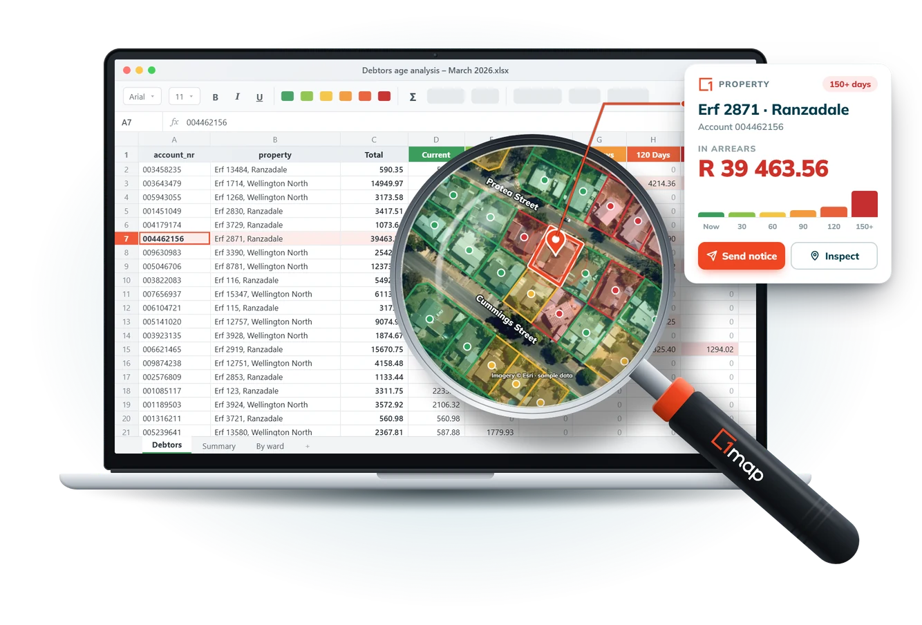
A debtors spreadsheet on a laptop. A 1map magnifying glass shows the same accounts as properties on a map, coloured by how long they are in arrears, with one property's card open to send a notice

The Core

One Map for All

A plug-and-play platform, that helps your team see its data in its real-world context.

Does this sound like you?

  • Property Professionals › – “I need access to the latest SG data where and when I want it”
  • Network Operators › – “I need to increase take-up on my lines, but I don’t know where the gaps are”
  • Municipalities › – “I know there is revenue leakage, but I don’t know how to find the problems”
  • Developers › – “International address APIs struggle with South Africa’s stand number addresses”
1map on a laptop: aerial imagery with property boundaries, fibre routes, water meters and accounts in arrears on one map, an erf’s SG details open, and the team workspace shared with four teams

Access and Control

Control Who Sees What

We want you to have peace of mind. Decide who can see what, so everyone has the access they need and nothing more.

Does this sound like you?

  • Network Operators › – “My contractors need the sites they’re working on, not the whole network”
  • Municipalities › – “We prioritise protection of personal information between departments”
  • Data creators › – “We want to share our maps without maintaining our own map servers”
1map viewed as a contractor: only Area 4 and its sites show, everything outside is hidden, customer details are hidden, and the role’s view, edit and download rights per layer

Integration

Use Your Own Data

Connect the data that you already have. Link asset and billing registers, bring in network inventory, or combine valuation and deeds, all set up your way.

Does this sound like you?

A billing register, asset register, network inventory, valuation roll and deeds flowing into 1map, matched on erf, address or account number, with an erf flagged where the billing and valuation land use differ

Field Work

Integrated Mobile App

Take the map into the field with 1map FieldApp. Record site visits, installations and boundary checks as they happen, all from the convenience of your mobile device.

Does this sound like you?

1map FieldApp on a phone recording an installation with photos, and the office’s 1map on a tablet showing it synced a moment later

Embed

Widget

Bring 1map’s maps into your own space, with just a few lines of code. Easily customise its styling to your specifications.

Does this sound like you?

The 1map Widget on a company’s own web page, searching South African addresses, erf and stand numbers in the company’s colours, beside the few lines of code that embed it

Works With the Systems You Already Use

* All trademarks and logos are the property of their respective owners and are shown for identification only. Their use does not imply endorsement by, sponsorship by or partnership with 1map.

You Control Your Data

Open formats, no lock-in

Your work shouldn’t depend on our file formats. Export your layers as Shapefile, GeoPackage, GeoJSON, CSV or Excel, so your data goes wherever you need it.
Hosted where you need it

You decide where your data lives. We can host your data on our servers, or help you set up a database on your own infrastructure.

Permissions you set

Decide who can view, edit or download each layer. Set access by assigning roles, so everyone sees what they need and nothing more.

Ready to see your data in context?

Let’s chat about how we can empower your organisation.